

We made three stops in Maine, but our focus was on Acadia National Park — mainly because neither of us had ever visited the park.
Maine, the 34th state we have visited on this road-trip, is an interesting state…. known as the The Pine Tree State, it is known for its wild blueberries and lobsters (lobstahs), 3,500 miles of rugged coastline, 4,000 (or so) islands dotting that coastline, 17 million acres of beautiful forests, and rolling mountains (mostly in the west and part of the Appalachian range). It is the only state in the U.S. to border just one other state. The state animal is the moose — and we saw moose images on everything (and moose crossings warnings on the roadways) — but we never saw one moose! Not surprisingly, given its nickname, the state tree is the White Pine. No one is quite sure where the name of the state originates, but some think it is a simple as Maine for mainland — to designate the bulk of the land from the many islands off its shore.
Canaan
We started our travels through Maine in Canaan (located between Skowhegan and Pittsfield in Somerset County — about 45 miles west of Bangor), camping at another quite nice KOA.
Our main adventure here was hiking around another Lake George… this one much less touristy than the one in New York. Maine’s Lake George Regional Park is a day-use facility established in 1992; it is owned by the State of Maine, but managed by the non-profit Lake George Corporation. It is actually two parks in one — with an east and a west side — with the lake in the middle. Lake George is a quite pretty spring-fed body of water nestled within a steep valley. We decided to focus on the west side because it looked more challenging, and we hiked a 1.8-mile loop route that left directly from the parking lot up and into the woods and then down along the shores of Lake George. That route is now called the Warren Trail (and which seems to be a combination of trails, starting with the Foster Hill Trail, continuing on the Podooc Trail, and ending on the Fisher Hill Trail). Several other trails along that route can make the hike shorter. The east side has two other trails: the Pinnacle Trail and the Townsend Family Trail. Besides hiking, one can do multiple other activities depending on the season, from swimming and boating in the summer to ice-fishing and cross-country skiing in the winter.

We also had to do a little wine-tasting while in Maine and discovered a very cute and aptly named (since we value this insect highly in mosquito season) Dragonfly Farm & Winery, located in Stetson — about 25 miles northeast of Canaan and 20 miles northwest of Bangor.
The winery was closed the day we wanted to taste, but we emailed them and they were very accommodating in setting up an appointment. They produce seven whites, six reds, and many fruit wines. We love that all the grape wines are estate produced — from their vineyard grapes — and the fruit comes from a local company in Downeast Maine. The grape varietals include Frontenac, St. Croix, Sabrevois, Marquette, Louise Swenson, St. Pepin, Edelweiss, LaCrescent, and LaCrosse. We had a wonderful tasting experience, sampling a mix from all three of their types of wines. We had a hard time deciding, but ended up purchasing a bottle of their Rudy, a very delightful strawberry table wine. We also had to purchase two of their green-labeled wine glasses to remember the experience. (We have now collected a number of glasses from wineries, though these were the only ones we have purchased; the rest of the glasses came “free” with the tastings. We are still deciding what we will do with all of them at the end of the trip.)
Dragonfly Farm & Winery is just one of 32 participating members of the Maine Wine Trail. Most of the wineries are located along the eastern and coastal parts of the state, with one outlier way up in the northeast corner — Hidden Spring Winery in East Hodgdon.
Acadia National Park
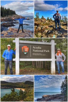
We then hooked up the trailer and laid tracks for Bar Harbor, the largest town on Mount Desert Island; its name comes from the famous sandbar that connects Bar Island to mainland at low tide… it is also home to Acadia National Park, the 41st national park we have visited on this trip. We stayed at the Bar Harbor/Oceanside KOA, another fine campground.
We quickly headed over to the Hulls Cove Visitor Center to get acquainted with the park and to speak with a ranger about the best hikes. We would have watched the park film, but they have removed the auditorium from the visitor center to accommodate all the crowds that come in looking for information and purchasing park passes. Wow… that was a first! (Last year, about 3.5 million people visited the park, making it one of the most-visited national parks in the country, just behind the Grand Canyon, Zion, and Yellowstone. The park’s busiest months are July, August, and September.) The ranger told us we could find the film online — Acadia Always — and we did. While at the visitor center, we also purchased a magnet for our collection.
Acadia National Park was first established in 1916 by President Woodrow Wilson as the Sieur de Monts National Monument (named for the natural springs located in the park). Three years later, Congress made it the Lafayette National Park — the first national park on the east coast. The park was renamed Acadia in 1929. Its mission is to protect about half of Mount Desert Island, as well as 18 other islands and part of the Schoodic Peninsula — and includes about 60 miles of rugged coastline. The park protects 49,000 acres, including 12,416 acres of privately owned lands that are under conservation easements managed by the National Park Service.
We decided the best way to orient ourselves was to drive the very scenic 27-mile Park Loop Road, which has numerous stops and overlooks — though our focus was on Sand Beach (shown in the pictures in the previous collage). Sand Beach is nestled in a small cove, with great views of the Atlantic Ocean to the east and Cadillac Mountain to the west. In the summers, Sand Beach is actually staffed with lifeguards.
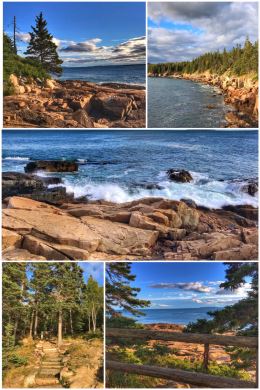
We weren’t planning to hike that day, but the weather was perfect, so we decided to hike on Great Head, a small peninsula located east of Sand Beach. The trail starts on the north end of the beach — and the full loop is about 1.4 miles. We hiked it clockwise and absolutely fell in love with Acadia on this hike. Everything about this hike is wonderful — the trees, the rocky coastline, the crashing seas, the beautiful vistas. Be forewarned that this hike should be considered moderate because there is some rock scrambling on the trail (and more off the trail if you like while exploring the coastline). That said, this hike is a must-do because of the diversity and awe-inspiring coast vistas.
Once back on the Loop Road, we decided on one more stop before the sun set… taking a short hike along the Ocean Path to Otter Point. The trail is fairly easy and the views spectacular… so definitely worthy as a stop.
One interesting side note… while we were on the Park Loop Road we noticed two large cruise ships docked near Bar Harbor. When we asked around, we discovered that cruise ships have become a big deal in the last decade — with close to 200 ships and 200,000 people “invading” Bar Harbor last year. It has become such a big influx that the city has actually capped how many tourists can come ashore. (Bar Harbor, by contrast, only has about 5,200 year-round residents.) The city also recently purchased an old ferry dock and are remodeling it so that some of the cruise ships can actually dock; right now passengers have to be shuttled to the island via small ships/ferries.
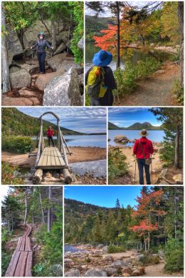
The next day we set out to hike around Jordan Pond and visit Cadillac Mountain, both in the central part of the park.
Jordan Pond is a 187-acre glacially carved pond (a 1-mile thick glacier once covered the area) … with Penobscot Mountain (1,194-feet) to the west, Pemetic Mountain (1,248 feet) to the east, and the Bubbles (two rock formations, each about 800-feet, created/carved by the passing glacier) to the north. The area is a popular spot, partly because of Jordan Pond House, which contains a gift shop — and a restaurant serving lunch and dinner, and known for its tea service and popovers. (There’s some controversy over the popovers as the original Maine-based concessionaires lost a renewal bid in 2013 and took their popover recipe with them to a new location in Northeast Harbor, while a company based in New Mexico took over the management; needless to say, we did not try the popovers, so we can’t speak to the controversy!) The multiple parking areas were completely filled when we arrived that morning, but after several impatient times circling and about to give up, we got a spot… so be prepared!
The Jordan Pond Trail is a 3.4-mile loop that we hiked counterclockwise… and which is fairly easy, though it does have some rock scrambling, lots of tree roots, and a long section of walking on a very narrow boardwalk.
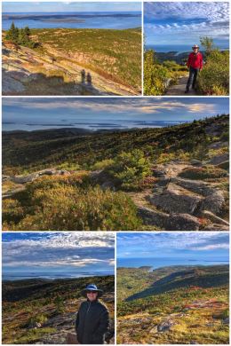
After the hike, we drove up to Cadillac Mountain on the 3.5-mile Summit Road, which was built in 1931. It is another of the 20+ mountains on Mount Desert Island, and, at 1,550 feet in elevation, it is the highest point along the North Atlantic seaboard. (The elevation may not seem that high, but it is amazing to think that these mountains would be much higher if not for the massive glaciers that sheared off their tops.) If you are so inclined, you can hike up the difficult 7.1-mile (RT) Cadillac Mountain South Ridge Trail rather than take the scenic drive. The views from the summit are quite spectacular — and most certainly worthy of a drive or hike up.
A few other fun facts about Cadillac Mountain. It used to be called Green Mountain — and in the late 1800s there was a hotel at the summit and a cog railway to reach it. The mountain was renamed in 1918 for French explorer and adventurer, Antoine Laumet de La Mothe, Sieur de Cadillac. The pink Cadillac Mountain granite is millions of years old.
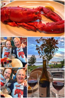
We capped off the day with a lobster dinner in Bar Harbor’s Galyn’s. You can barely go a block in any direction without finding a place (shack or restaurant) selling lobstah… but we wanted a full sit-down meal, which is why we chose Galyn’s. (Sadly, we found the lobster a bit overcooked and rubbery.) We had also considered trying a lobster roll later in the trip, but the dinner turned us off from doing so… as did the price! Full lobsters run around $30 each and a lobster roll can be $25+.
Lobster is a BIG business in Maine. Last year — and for the last several years — Maine’s lobstermen have harvested more than 110 million pounds of lobster, bringing in about $484 million at wholesale. And just in Bar Harbor, more than 5 million lobsters are eaten annually. Fun fact: Lobsters take about seven years to grow to legal one pound size for harvesting.
Our third day in Acadia was all about a third section of the park — and hiking up to another fire tower. On our first day, when we were told the Beech Mountain Fire Tower would be open on Saturday morning, we circled it on our calendar. Beech Mountain is only about 839 feet in elevation, but the summit offers excellent views of Echo Lake and the southwestern part of Mount Desert Island.
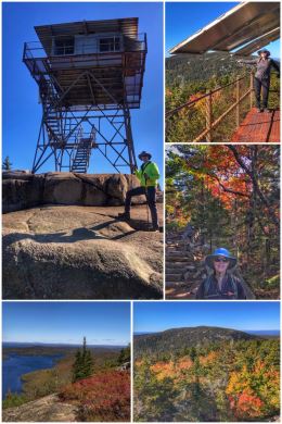
The original fire lookout was a wooden structure built by men from the Civilian Conservation Corps (CCC) and in use from the 1940s to 1950s. When the structure began deteriorating, a new steel tower was erected in 1962 — and stayed in use sporadically until 1976. The fire tower is on the National Registry of Historic Fire Towers and is usually not open to the public.
We arrived early (for us) and found a small, but fairly empty parking lot at the end of Beech Hill Road. We then hiked the 1.2-mile Beech Mountain Loop Trail up to the fire tower … and when we got back, the parking lot was full and there was a line of cars waiting for a space! The hike itself was wonderful and not terribly difficult, with numerous quite amazing vistas… whether the fire tower is open or not, this trail is a do-not-miss. And from the same parking area, you can also hike the Beech Mountain Valley Trail to South Ridge Trail. We chose not to because we had other items still on our agenda.

On our way back north on Beech Hill Road, we stopped at Beech Hill Farm, a certified organic farm that is part of the College of the Atlantic (COA) — a small (about 330+ students), private, liberal-arts college located in Bar Harbor. The campus consists of 37 acres on Frenchman Bay, two organic farms growing produce and meats, two off-shore island research stations, and a 100-acre protected area. The farms supply the all-organic meats, vegetables, and eggs to the campus cafeteria, as well as selling to the public.
Check out the mission of the Beech Hill Farm: “Beech Hill Farm produces certified organic food for COA and the Mount Desert Island community, while using methods that maintain the integrity and health of the land, and work toward environmental and economic sustainability.” Beech Hill Farm’s 73-acre property includes six acres of fields in vegetable production, three small heirloom apple orchards, pasture land for pigs and poultry, five greenhouses, and open forest.
We bought all sorts of goodies while there, including fresh eggs, local cream cheeses, and several onions and other veggies.

Back to Acadia… we decided to visit the fourth area of the park, located in the southern most part of the Mount Desert Island, starting with Bass Harbor Head Lighthouse, located off of Route 102A in Tremont. The lighthouse was built of brick in 1858 on a stone foundation, and stands 56 feet above mean high water. The original lighthouse lens was a Fifth Order Fresnel, which was later replaced by a Fourth Order Fresnel.
In 1988, the lighthouse was added to the National Register of Historic Places. A keeper’s house, which is now attached to the lighthouse, is closed to the public (as is the lighthouse itself). The United States Coast Guard operates and maintains the lighthouse and surrounding buildings. A short walk from a small parking area provides views of the lighthouse and the waters beyond.
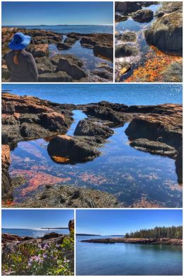
On our way back north along Route 102A, we decided to also hike the 1.3-mile double-loop Ship Harbor Nature Trail. We stuck to a left-side, clockwise approach to hiking the trail… which means we hiked through beautiful forest on the first half, and then along the rocky harbor side on the way back to the parking area. We absolutely loved the pink granite sheets and numerous tide pools found along this shallow inlet.
Believe it or not, we had one last hike to do in Acadia, so we headed back north on Route 102 and then around and south on Route 198… striving for a hike to Upper Hadlock Pond via one of the Carriage Roads.
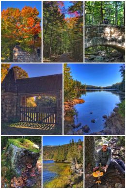
Wait. What? Yes, there are 45 miles of 16-foot-wide rustic carriage roads throughout Acadia National Park… a gift from John D. Rockefeller Jr., an avid horseman who wanted non-motorized trails throughout the park for horses and horse-drawn carriages. Constructed between 1913 and 1940, these roads were built into the landscape and geography of the park, partly to make them more natural and partly to take advantage of scenic views along the way. The roads are easy to hike or bike because they were designed so that no grades were too steep nor curves too sharp… for those carriages. Large blocks of granite along the roads serve as guardrails. Along the routes, there are 17 stone-faced bridges, each unique in design. Two gate lodges serve as welcome entries to the system. We parked just north of the Brown Mountain Gate House.
But why John Rockefeller? Well the Rockefellers, Astors, Vanderbilts and Carnegies all homesteaded in Acadia during the Gilded Age, building mammoth 1,000-room hotels and opulent mansions they coyly referred to as summer “cottages.” Sadly, much of that fell to ruin in 1947 when a fire roared across the island, consuming scores of mansions and scorching thousands of acres of the park.
Back to Hadlock Ponds (which are both actually reservoirs for drinking water). We ended up completing a pretty amazing and scenic 4-mile loop around both Hadlock Ponds, starting first on the carriage road up to the Hadlock Brook Bridge (built in 1926). We then exited off the carriage road onto Hadlock Ponds Trail, which follows the southeastern shores of Upper Hadlock Lake, crossing over Route 198 (where there is also a very tiny parking area) and south along Hadlock Brook toward Lower Hadlock Pond, following the east side of the pond, turning east and again crossing Route 198 — ending up right at the Brown Mountain Gate House… and a short walk back to our truck.
Some final comments on Acadia. First, it can be busy and crowded, but the scenery is spectacular and there are a lot of less-visited places to find peace on the trails. Second, this park is yet another where the efforts of one man — in this case George Dorr — resulted in the preservation of the land and the eventual creation of the national park. It was his original 6,000 acres that became the national monument… but that was not enough, so he continued to acquire land and push for a national park; when it became a national park, Dorr became the first park superintendent.
If you do not want to drive in the park (which can be a bit frustrating at times, especially looking for parking), there is a free Acadia shuttle — the Island Explorer. One can also do both scenic boat and plane rides over Acadia and the seven coastal lighthouses in the area. Almost whatever you want to do, you can do it here.
Freeport… Last Stop in Maine
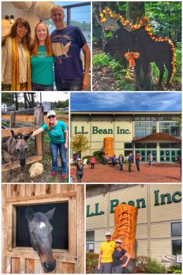
After a wonderful visit to Acadia, it was time to work our way south, with a stop in Durham in southwest Maine… near Freeport, home of L.L. Bean. We stayed at another nice KOA; this campground had a very friendly owner, good amenities, and a nature trail that leads to the owner’s horses, chickens… and one donkey!
The highlight of this location, though, had to be meeting up with Ran’s cousin Jennifer, who he had not seen in several decades. We had a lovely visit with Jen, and hope to visit with her again down the road… or perhaps she and her family will make it out to Washington once we build our house.
We had already been considering it, but Jennifer made a strong case for visiting L.L. Bean, the outdoor supply company that is based in Freeport — and which has a massive complex there (including a store for clothing, a store for fishing and hunting, and store for home furnishings). The stores are open 24/7, all 365 days a year. We wandered around and gasped at some of the prices, but Ran was lucky enough to find a flannel shirt on clearance. While many love the store — and its guarantee of quality (and one-time unlimited returns, which are now limited) — the store is not without controversy as one of the heirs and owners of the still private and family-owned retailer donated a large amount of money to a political action committee that supported the election of Donald Trump. The company itself made it clear that it does not support any political party.
L.L. Bean was founded in 1912 by its namesake, hunter and fisherman Leon Leonwood Bean — who started a mail-order business in Freeport selling only one item… the Maine Hunting Shoe, also known as Duck Boots. Today, the company has 55 stores and 5,000+ employees — and an annual revenue of $1.6+ billion.
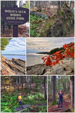
After shopping, it was time to get back into nature with a state park that Jennifer recommended we visit… the 244-acre Wolfe’s Neck Woods State Park, located on Casco Bay and along the Harraseeket River on the southeastern side of Freeport. The park contains varied ecosystems, including forests of white pine and hemlock, a salt marsh estuary, and very cool rocky shorelines. One of the key draws for many are the ospreys who nest on nearby Googins Island. (The birds were on their annual trek to South America when we visited.)
The park offers a network of shorter trails totaling about 4.4 miles. We cobbled together several of them into a counterclockwise loop through the majority of the park. (Many connecting trails lead directly from the large parking area.) We started briefly on the Old Woods Road Trail from the parking lot, which connects to the main trail we hiked — Harraseeket Trail. We then connected with the Casco Bay Trail before hiking a bit of the White Pines Trail (through the picnic area) to return back to the parking lot. Our loop hike was about 2.3 miles.
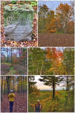
We wanted a bit more hiking in, so we crossed town over to Hedgehog Mountain, a 196-acre mature pine and hemlock woodlands owned by the Town of Freeport with about 5 miles of connecting trails. It is located just off Pownal Road, with a parking area right before the recycling center.
Probably the main trail folks hike is the Summit Trail, which takes you to the highest point in Freeport… and we started with this very short, but somewhat steep trail to the top. We then looped down and around hiking mostly the Hedgehog Trail, which connects back to the parking area… for a total again of about 2.3 miles… and making it about 5 miles for the day. Perfect.
Back at the campground, we enjoyed visiting the horses and the donkey we named Lumpy (see the picture), but whose real name was Mr. D. Have we mentioned how much we love camping after Labor Day, when the kids are back in school and the campgrounds are generally quiet and uncrowded?
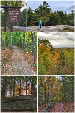
We ended our time in Maine with one more hike… at the nearby Bradbury Mountain State Park, a 730-acre facility located in Pownal and established in 1939 — one of Maine’s first state parks. Sculpted by a glacier, Bradbury Mountain is the park’s most outstanding natural feature — and a short, but relatively steep hike to the 485-foot summit offers beautiful views of the surrounding area. In the 1940’s, the park offered downhill skiing with a rope tow — and today one of the trails you can hike is the Ski Trail.
We parked on the west side, near the picnic area… which leads directly to the Summit Trail. Once at the summit, you have several options. You can hike back down the .3-mile Summit Trail or do a loop via the .3-mile Switchback Trail… or hike the 1-mile Tote Road… or go for a longer hiker along the 1.5-mile Boundary Trail (which literally follows the park’s property line)… or hike the 1-mile Northern Loop, which is what we did… adding a bit the Boundary Trail on the north side of the park, returning to the Northern Loop back to the parking lot… for a total hike of about 2 miles. The east side of the park has a few more trails, totaling more than 5 miles… so a full day could result in a decent amount of hiking.
The park is open year-round and the trails are open to hikers, mountain bikers, horseback riders, cross-country skiers, and snowshoers. There’s even a 35-site primitive campground.
Next up, we continue moving south, with quick stops in Massachusetts, Rhode Island, and Connecticut.